Scorned on the Bayou
Louisianans fear a new plan to restore costal wetlands could destroy their way of life
Melinda Tuhus

George Barisich has been shrimping and oystering in the Louisiana bayous – “everywhere I can float,” he says – for 40 of his 50 years. He harvests oysters in brackish water (mixed salt and fresh) since they grow only in a certain salinity, and he catches shrimp from eastern Mississippi to western Louisiana, mostly on inland bays and lakes.
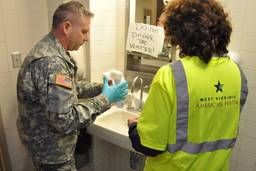
He’s one of 6,000 commercial fishing license holders in Louisiana, although since the 2005 hurricane season only 1,500 of them have been able to return to work – the boats of the rest were destroyed. And there’ll always be a spot on board for his sons if they decide to follow in his footsteps – as he did in his father’s. But, he says, “a crash is coming,” probably within the next decade, unless the commercial fishermen, the U.S. Army Corps of Engineers, environmental advocates, oil and gas companies, and the state and federal governments can agree on a plan to stop, if not reverse, the loss of the wetlands that provide the richest seafood harvest in America.
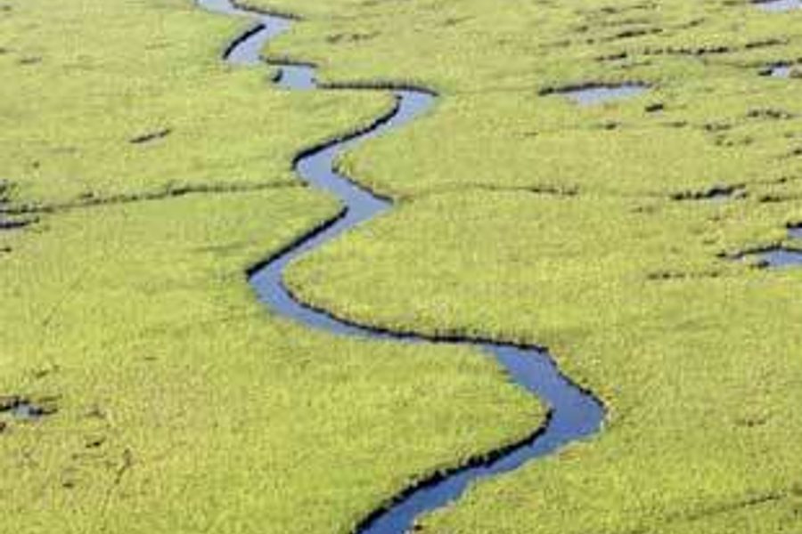
In late August and September 2005, the one-two punch of hurricanes Katrina and Rita battered the Louisiana Gulf Coast and obliterated 200 square miles of wetlands, greatly exacerbating the ongoing wetlands loss due to long-term natural processes and human activity. Since the ’30s, more land has disappeared more quickly off the Louisiana coast than anywhere else in the world – the equivalent of a football field every 45 minutes.
For many years this rich ecosystem – which ranges from saltwater to brackish to freshwater and which is home to a fascinating array of shellfish, fin fish and the birds and other animals that feed on them – was dismissed as merely “swamp.” But for at least three decades, its disappearance has alarmed scientists, government officials and those who depend on the estuaries for their livelihoods and their Cajun way of life – in which fishing and trapping have provided sustenance and a degree of independence from mainstream American culture, not to mention fabulous food and memorable music. Many plans for restoring the wetlands – or at least slowing their destruction – have emerged. Action has been harder to come by.
— — — — — — — —Look at a map of Louisiana and you’ll see the fingers of land that brush the Gulf of Mexico. These fingers were built up over thousands of years by the rich silt deposits carried by the Mississippi River to its mouth. Over time, the silt compacts and the land sinks, in a process called natural subsidence. This ecosystem includes the remaining barrier islands in the Gulf, salt marsh, brackish marsh, freshwater marsh and hardwood forests, ranging from lowest elevation to highest, which is still just a few feet above sea level. But since levees were built by the Corps of Engineers beginning a century ago to channel the river and control its natural flooding in order to protect industrial infrastructure and the residents, the silt – 400 million tons every year – has been dumped uselessly into deep Gulf waters, resulting in no new land-building. In addition, since the ’30s, the oil and gas industry has bulldozed 8,000 miles of canals throughout the wetlands to carry on its business, a process that experts – like Mark Davis, director of the Institute on Water Resources, Law and Policy at Tulane University – say accounts for about 35 percent of the destruction.
The Barataria and Terrebonne estuaries – which encompass four million acres of the very richest and fastest-disappearing part of the Louisiana Gulf coast – produce nearly 20 percent of the nation’s annual seafood catch from mixed salt and fresh water. Louisiana Highway 1 bisects the two estuaries, and leads to Port Fourchon on the edge of the Gulf. The port is a vital energy hub, handlng almost a fifth of domestic oil production and 14 percent of the crude oil imported into the United States. The telephone poles paralleling the road now stand in several feet of water, and low-lying graveyards are relinquishing their dead to the sea. Off the coast, Grand Isle stands as one of the last remaining barrier islands that buffer wetlands from Gulf storms.
Barisich, president of the United Commercial Fishermen’s Association in Louisiana, says he and others have been asking the Corps and the state and federal governments for years to build a rock jetty to protect the island, to no avail. “The money they spent on studies alone in the last 30 or 40 years, they could have paid to put the rocks all the way across there,” he says. “Or, pump the sand – the sand’s right there. Pump it up from the Gulf, and build your levees, outside. You need that barrier reef.”
Destroying a way of life
A comprehensive plan to save the Mississippi’s estuary has been developed by dozens of groups brought together by the Barataria-Terrebonne National Estuary Program, or BTNEP. Congress created the National Estuary Program in 1987 to improve the quality of estuaries – “places where rivers meet the sea,” according to the Environmental Protection Agency (EPA). The EPA oversees the 28 estuaries of national significance, including Chesapeake Bay and Long Island Sound. BTNEP encompasses the heart of bayou country, bounded by the Mississippi River in the east and the Atchafalaya River in the west.
In 1996, BTNEP came up with a Comprehensive Coastal Management Plan to help preserve the wetlands within its boundaries in a way that balanced the needs of the various stakeholders. The plan included small water diversions and land-building by piping in sediments from nearby areas to restore the wetlands, says BTNEP Executive Director Kerry St. Pé, from his map-cluttered office at Nichols State University in Thibodeaux, La. “That allows us to put the sediments where we need them in the shortest period of time,” he says. The plan was approved by both the state of Louisiana and the EPA, but little has been implemented.
However, no price tag was attached to the plan. “The scope of what we’re talking about is incredible. It would have been ridiculous to put a price tag on it,” says St. Pé, because the situation is constantly changing. He did note that restoring a single barrier island costs $27 million. In 1998, the Corps of Engineers released its Coast 2050 plan, a $14 billion proposal that, if fully implemented, would have protected or restored almost half a million acres of wetlands in the Barataria basin. (St. Pé calls that estimate “a very conservative guess.”) But that was deemed too expensive by the federal government, which requested a $2 billion version, which Congress was considering when the hurricanes struck in 2005.
After the hurricanes, the state of Louisiana formed the Coastal Protection and Restoration Authority (CPRA), which released its plan in April. Its executive summary states, “Coastal restoration measures are identified based on the premise that restoring sustainability to the coastal landscape is a priority. Diversions of Mississippi and Atchafalaya River water are, therefore, prominent in the plan.”
These massive freshwater diversions would mimic the land-building of the untamed Mississippi River of old, but would also bring major salinity changes to the wetlands system that St. Pé says will not be acceptable to all the stakeholders, especially the residents of the bayous.
“It would destroy our way of life. It would annihilate it,” says St. Pé, whose family has lived in the area for seven generations. Each kind of shellfish or fin fish in the area flourishes in water with a different level of salinity, from the salt marsh nearest the Gulf to brackish, to freshwater marsh further inland. “You can’t raise oysters, you can’t catch brown shrimp, you can’t catch blue crabs or spotted sea trout in a freshwater system,” he says, “and these mega-water diversions from the river would cause the Barataria to become largely fresh.”
— — — — — — — — —In May, the CPRA plan sailed unanimously through both houses of the Louisiana legislature and was also approved by Democratic Gov. Kathleen Babineaux Blanco. But implementation must await the final plan of the U.S. Army Corps of Engineers, due this December, which will include technical implementation details.
Many in coastal Louisiana are unimpressed with the Corps. Environmentalists, commercial fishers and residents all complain that the Corps engages in endless planning and evaluation but drags its feet on implementation.
Greg Miller, project manager for the Corps in Louisiana, says the relationships between the different governmental bodies are convoluted. “We work at the direction of the president of the United States and the United States Congress, and the state of Louisiana works at the direction of the governor of the state and the legislature, and those are two very different forms of authority.”
Miller acknowledges that the BTNEP plan involved more than a hundred representatives of scores of groups, but adds, “The world is a very different place in south Louisiana now because of Hurricanes Katrina and Rita,” he says. “Our intent is not to reinvent the wheel but to incorporate what’s still valid into our effort.”
At the Institute on Water Resources, Law and Policy, one of several nonprofit groups concerned with protecting the wetlands, Mark Davis laughs when asked about the collaboration of state officials with the Corps. “They collaborate like the Israelis and Palestinians.” Davis is worried that more resources and planning will go toward hurricane protection than coastal restoration. While this reallocation is understandable in light of Katrina, it could prove harmful.
“The state plan is very, very heavy on levees,” says Mark Ford, executive director of the Coalition to Restore Coastal Louisiana. “With the focus on levees, we fear there won’t be anything left over for restoration elements.” Levees intended to keep floodwaters out of cities like New Orleans and smaller coastal communities also separate those communities from the cyclical river flooding and natural land-building that created the bayous in the first place.
Enter the concept of “leaky levees.” After joking that those are the levees around New Orleans, Ford says that one proposal in the state plan is to construct levees with gates built into them that would allow water exchange, but would still keep tidal surges out during storms. “It’s just a concept,” he says. “We don’t know if it will work, but it means a lot of structures, which means a lot of money and we think it’s going to fall to parishes [counties] to operate them, which may not be viable, in which case they would close and we’d be even worse off.”
Davis says there are definitely good aspects to the state’s plan. “The Corps is not responsible to communities and the culture and economy and environmental heritage issues the way the state is. The state has to set the tone, even though it can’t single-handedly implement things.” But he agrees with Ford that “the plan promotes levees first and hopes the other elements fit in.”
Letting industry off the hook
The oil and gas industry, which is responsible for much of the wetland destruction, has not offered to help offset the damage it has caused. Instead, it funds a public relations campaign urging other sectors to fund the actual restoration work.
“You have to remember, when we started drilling the wetlands back in the ’30s or ’40s, no one thought they had any value; it was just swamp land,” says Larry Wall, spokesman for the Louisiana Mid-Continent Oil and Gas Association. “And people wanted the oil and gas removed. So using the best technology we had then, we dug canals to get drilling rigs to the site, to get people in and out of the site. We built canals, we built border roads – we did a lot of things we wouldn’t do today. Did we do it on purpose? No. Who knew? It just wasn’t a big issue then and no one recognized the full impact. Now, from about the 1980s, we changed things. We quit using pits, we started mitigating canals by filling in one if we built another, we tried to lessen the footprint of drilling activities.”
Advocates of restoration say the state and federal government have let a politically powerful industry off the hook.
Sport fishermen (some Louisiana license plates still proclaim the state a “Sportsmen’s Paradise”) add to the problem as well, by motoring through the canals and bayous at speeds that cause wave damage along the shore, contributing to erosion. Signs posted by local authorities in Bayou La Fourche calling for a slow speed limit or “no wake” are routinely ignored.
The cost of the war in Iraq juxtaposed to the lack of investment in coastal Louisiana is a sore point with those wanting to preserve the estuary – especially U.S. tax dollars spent to restore the marshes in Shiite-dominated southern Iraq that were drained by Saddam Hussein after the Shiites’ failed uprising in the early ’90s.
“We restored their wetland,” says Ford. “We could do ours for $30 billion.” A $30 billion investment is the equivalent of 109 days of the war.
BTNEP’s Kerry St. Pé sounded discouraged in an e-mail message about the current state of affairs. “The new state master plan simply has restoration measures in it that deviate from and contradict the restoration agreement that the National Estuary Program was invented to create,” he wrote, noting that hundreds of people, including representatives from the Louisiana Department of Natural Resources, the U.S. Army Corps of Engineers and the governor’s office worked for five years to create the agreement.
He concluded that many of today’s players at the state and federal levels were not around while the BTNEP plan evolved over the past 15 years. “So we are considered to be just another voice among many, and not the congressionally mandated, watershed-level planning network that we are,” he wrote. “The Estuary Program blended the hundreds of opinions into one consolidated plan. That is of particular and noteworthy value when it is necessary to restore such a complex place. It just needs to be used.”