Over 10,000 Firefighters Are Battling Eight Large Wildfires in California
Rural America In These Times
Daniel Berlant, the chief public information officer for the California Department of Forestry and Fire Protection (CAL FIRE), is providing frequent updates on the wildfires sweeping across the state via Twitter and recently announced that over 10,000 firefighters are currently battling eight large wildfires in the state — two of which ignited in the last 24 hours.
The Blue Cut Fire near San Bernardino’s Cajon Pass, now covering 30,000 acres, has destroyed “numerous structures” and poses “imminent threat to public safety, rail traffic, and structures in the Cajon Pass, Lytle Cree, Wrightwood, Oak Hills and surrounding areas.” At the time of this release, the blaze was zero percent contained.
Unfortunately, the 2016 fire season is far from over.
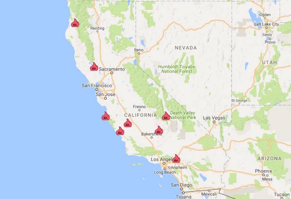
Fires currently burning in California. (Photo: California Department of Forestry and Fire Protection)
Speaking to the Los Angeles Times, battalion chief for the San Bernardino County Fire Department, Michael Wakoski, said he hadn’t seen anything like the fire in his 40 years at the department. Though crews worked to get ahead of the blaze when it started early Tuesday, dry and windy conditions made it impossible. “It’s a disaster that has been waiting to happen all year, waiting for a spark,” said Wakoski adding, “We got our butts kicked.”
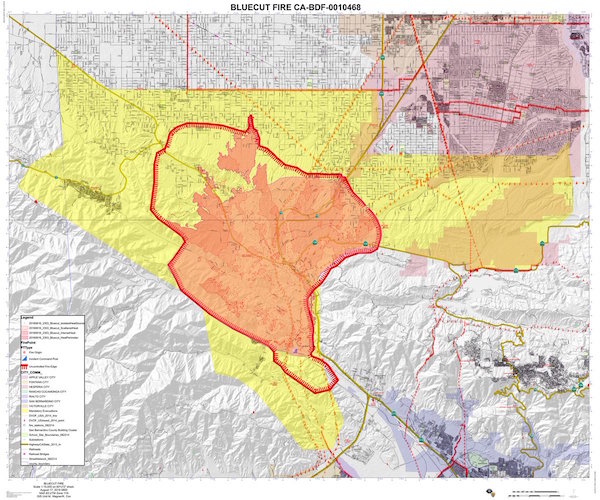
Latest map of Blue Cut area burned. (Image: Janice Rutherford / Twitter)
According to CAL FIRE as of 8/17/16: “A Red Flag Warning remains in effect for the mountains and desert foothills of Los Angeles, Ventura, San Bernardino, Riverside and San Diego counties. Gusty winds, low humidity and high temperatures bring elevated fire danger to the area. In northern California, a Red Flag Warning is in effect in western Siskiyou County for strong winds and low relative humidity.”
BLUECUT FIRE: more info…
Updated: August 17, 2016 7:15 am
County:
San Bernardino County
Location:
off of I-15 and Hwy 138, north of San Bernardino
Acres Burned - Containment:
30,000 acres
Evacuation Info:
The entire community of Wrightwood West of I-15, and West of Hwy 395 and west of Summit Valley North of Bear Valley Rd. and East of Caughlin Road. North of 138, east of Sheep Creek, south of Phelan Rd. and west of Caliente, Lone Pine Canyon, Swarthout Canyon, West Cajon Valley, Lytle Creek Canyon
CEDAR FIRE: more info…
Updated: August 16, 2016 7:15 pm
County:
Kern County
Location:
off of Hwy 155 in the Greenhorn Mountains, west of Wofford Heights
Acres Burned - Containment:
**This is NOT a CAL FIRE incident. For more information, click on the link above.
MINERAL FIRE: more info…
Updated: August 17, 2016 7:00 am
County:
Fresno County
Location:
off Hwy 198 & Mineral Springs Rd, W of Coalinga
Acres Burned - Containment:
7,050 acres - 98% contained
Evacuation Info:
No current evacuation warnings or orders.
CHIMNEY FIRE: more info…
Updated: August 17, 2016 7:30 am
County:
San Luis Obispo County
Location:
Running Deer Rd & Chimney Rock Rd south of Lake Nacimiento
Acres Burned - Containment:
7,300 acres - 25% contained
Evacuation Info:
Mandatory: The Communities of Running Deer Ranch, Tri-County, Cal Shasta, Rancho de Lago, and South Shore Village
CLAYTON FIRE: more info…
Updated: August 17, 2016 6:15 am
County:
Lake County
Location:
off Hwy 29 and Clayton Creek south of Lower Lake
Acres Burned - Containment:
3,929 acres - 40% contained
Evacuation Info:
Evacuation Orders and Center Information.
As of 3 PM - August 16 - Neighborhoods east of State Highway 53 from Polk Avenue south to Cache Creek. This includes the area of Clearlake referred to as “The Avenues.”
Evacuations: Mandatory: Clayton Creek Road, all of Morgan Valley Road, North Spruce Grove Road to Jerusalem Grade.
Advisory: Jerusalem Grade Road
Evacuation Centers:
Seventh Day Adventist Church, 3500 Hill Rd. E., Lakeport, CA 95453
Kelseyville High School, 5480 Main Street, Kelseyville, CA 95451
Twin Pines Casino, 22223 Hwy 29, Middletown, CA 95461
Whether in a vehicle, on foot, or in a structure, for imformation about what you should do if surrounded by a wildfire visit http://www.readyforwildfire.org/What-To-Do-If-Trapped/